More Rain Keeps Flooding Threat in Indiana This Weekend
INDIANAPOLIS — Rain on Saturday keeps the risk of flooding around for the weekend across Indiana.
Showers and thunderstorms move through central Indiana from Illinois Saturday morning. With all the rain the state has already seen this week, Jason Puma from the National Weather Service in Indianapolis called it “a significant event in central Indiana weather history.”
“There’s not a lot of places for this water to go other than to start running off and resulting in flooding or making existing flooding worse,” said Puma.
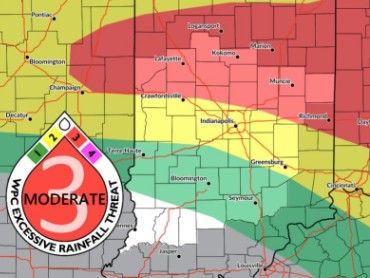
A Flood Watch remains in effect for much of the state through Sunday morning. NWS issued flash flood warnings for Boone, Clinton, Carroll, Delaware, Fountain, Hamilton, Hancock, Hendricks, Henry, Madison, Marion, Tippecanoe, Tipton, Vermillion, and Warren counties.
“There have been a few spots that have had around 10 inches or so over the course of the week, and there’s probably a few isolated higher amounts as well,” Puma added.
Puma is reminding Hoosiers to never drive through flooded roadways, as water depths can be deceptive and conditions can deteriorate rapidly.
“Don’t let kids play near floodwaters and don’t go kayaking in the river,” Puma said. “Floodwaters are nothing to mess around with.”
Included in Saturday’s weather system are lightning and wind gusts up to 40 mph. There is also a heat advisory covering the south-central and southwestern portions of the state, with highs in the mid to upper 80s.
More Rain Keeps Flooding Threat in Indiana This Weekend was originally published on wibc.com