NWS: Warming Up in Central Indiana
STATEWIDE — After a weekend of light snow and sub-zero chills, Central Indiana is looking is finally looking at a reprieve from the “worst of the cold.”
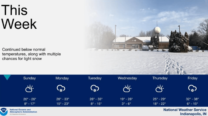
National Weather Service meteorologist Andrew White says that while some spots started Sunday as low as -10 degrees, the region is trending toward a slow thaw.


“The worst of the cold is going to be behind us,” White says. “We’re expecting to see temperatures in the low to mid 20s Sunday and then we’re looking at the potential of seeing 30s for a couple of days this week.”
The relief comes with a few minor catches.
Wednesday is set to be the week’s coldest day following that second wave of snow, but the real highlight for cabin-fever-stricken residents arrives at the end of the week.
“Our warmest day, we’re expecting it to be Friday,” White notes. “We’re going to have temperatures in the mid 30s when it comes to the weekday temperatures.”
While a high of 40 is on the horizon for the following week, don’t expect the white landscape to vanish immediately. White predicts that based on current temperatures and upcoming precipitation, there will likely be some snow on the ground until at least Valentine’s Day.
For those heading out, he warns that while roads are treated, the lingering cold makes salt less effective, so drivers should remain alert for slick spots during the morning commutes.
NWS: Warming Up in Central Indiana was originally published on wibc.com